Geolocate

Belora topographic map

Click on the map to display elevation.

About this map

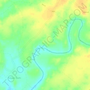
Name: Belora topographic map, elevation, terrain.

Location: Belora, Chandurbazar, Amravati, Maharashtra, India (21.20752 77.63300 21.23372 77.65165)

Average elevation: 1,168 ft

Minimum elevation: 1,112 ft

Maximum elevation: 1,214 ft

Gear up for your next adventure:

🔥Fast-Boil Camping Stoves - Efficient cooking systems for quick trail meals
🪶Wildlife Field Guides - Learn animal tracking and species ID
📦Dry Bags Set - Waterproof storage for electronics and clothes
🧥Men's Rain Shells - Premium waterproof and breathable jackets for mountain weather
🔦Compact Flashlight - Reliable flashlight for emergencies

As an Amazon Associate, this site earns from qualifying purchases at no extra cost to you.