Geolocate

Nazareth topographic map

Click on the map to display elevation.

About this map

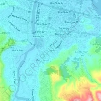
Name: Nazareth topographic map, elevation, terrain.

Location: Nazareth, Cagayan de Oro, Northern Mindanao, 9000, Philippines (8.44934 124.62704 8.48934 124.66704)

Average elevation: 108 ft

Minimum elevation: -13 ft

Maximum elevation: 679 ft

Other topographic maps

Click on a map to view its topography, its elevation and its terrain.

Calaanan Creek

Philippines > Cagayan de Oro

Average elevation: 230 ft

Gear up for your next adventure:

🥘Titanium Cookware - Durable, featherlight pots and pans for backpacking
🪶Paracord Bracelet - Survival bracelet with built‑in tools
🎒Waterproof Dry Bags - Keep your electronics and maps dry inside your pack
🧤Tactile Hiking Gloves - Keep hands warm while operating GPS and smartphone screens
🎒Day Hiking Backpack - Lightweight backpack perfect for day trips and outdoor adventures

As an Amazon Associate, this site earns from qualifying purchases at no extra cost to you.