
Make a donation
Gear up for your next adventure:
As an Amazon Associate, this site earns from qualifying purchases at no extra cost to you.
Seia topographic map
Click on the map to display elevation.
Make a donation
Gear up for your next adventure:
As an Amazon Associate, this site earns from qualifying purchases at no extra cost to you.
Seia
The municipality is limited to the north by the municipalities of Nelas and Mangualde, to the northeast by Gouveia, to the east by Manteigas, to the southeast by Covilhã, to the southwest by Arganil and to the west by Oliveira do Hospital. In this municipality is located the highest point in mainland Portugal, Torre, in Serra da Estrela, with 1,993 meters of altitude. The municipality of Seia covers a large part of Serra da Estrela and is also the only one in Portugal where there is a natural ski resort, Vodafone Ski Resort, located within the limits of the parish of Loriga.
Make a donation
Gear up for your next adventure:
As an Amazon Associate, this site earns from qualifying purchases at no extra cost to you.
About this map
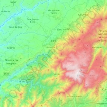
Name: Seia topographic map, elevation, terrain.
Location: Seia, Guarda, Portugal (40.22992 -7.84923 40.53552 -7.58343)
Average elevation: 2,474 ft
Minimum elevation: 492 ft
Maximum elevation: 6,526 ft
Make a donation
Gear up for your next adventure:
As an Amazon Associate, this site earns from qualifying purchases at no extra cost to you.
Other topographic maps
Click on a map to view its topography, its elevation and its terrain.