
Thank you for supporting this site ❤️
Make a donation
Make a donation
Gear up for your next adventure:
As an Amazon Associate, this site earns from qualifying purchases at no extra cost to you.
Akka topographic map
Click on the map to display elevation.
Thank you for supporting this site ❤️
Make a donation
Make a donation
Gear up for your next adventure:
As an Amazon Associate, this site earns from qualifying purchases at no extra cost to you.
About this map
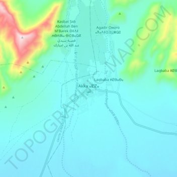
Name: Akka topographic map, elevation, terrain.
Location: Akka, Pachalik d'Akka, Province de Tata, Souss-Massa, Maroc (29.35186 -8.29676 29.43186 -8.21676)
Average elevation: 1,896 ft
Minimum elevation: 1,594 ft
Maximum elevation: 3,606 ft
Thank you for supporting this site ❤️
Make a donation
Make a donation
Gear up for your next adventure:
As an Amazon Associate, this site earns from qualifying purchases at no extra cost to you.