
Make a donation
Gear up for your next adventure:
As an Amazon Associate, this site earns from qualifying purchases at no extra cost to you.
Centro topographic map
Click on the map to display elevation.
Make a donation
Gear up for your next adventure:
As an Amazon Associate, this site earns from qualifying purchases at no extra cost to you.
About this map
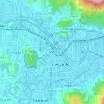
Name: Centro topographic map, elevation, terrain.
Average elevation: 177 ft
Minimum elevation: 69 ft
Maximum elevation: 1,030 ft
Make a donation
Gear up for your next adventure:
As an Amazon Associate, this site earns from qualifying purchases at no extra cost to you.
Other topographic maps
Click on a map to view its topography, its elevation and its terrain.
Jaraguá do Sul
Brasil > Santa Catarina > Jaraguá do Sul
Jaraguá do Sul é um município brasileiro do estado de Santa Catarina. Localiza-se a uma latitude 26º29'09" sul e a uma longitude 49º04'01" oeste, estando a uma altitude de 30 metros. Possui uma área de 532,59 km².
Average elevation: 623 ft