
Make a donation
Gear up for your next adventure:
As an Amazon Associate, this site earns from qualifying purchases at no extra cost to you.
Kaifu topographic map
Click on the map to display elevation.
Make a donation
Gear up for your next adventure:
As an Amazon Associate, this site earns from qualifying purchases at no extra cost to you.
About this map
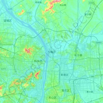
Name: Kaifu topographic map, elevation, terrain.
Location: Kaifu, Kaifu District, Changsha, Hunan, 410003, China (28.09931 112.82067 28.41931 113.14067)
Average elevation: 187 ft
Minimum elevation: 59 ft
Maximum elevation: 1,115 ft
Make a donation
Gear up for your next adventure:
As an Amazon Associate, this site earns from qualifying purchases at no extra cost to you.
Other topographic maps
Click on a map to view its topography, its elevation and its terrain.
Changsha County
Changsha County is located in the northern part of the Changsha-Hengyang Hilly Basin (Chinese: 长衡丘陵盆地). It is located at the southern end of the Mufu Mountains, Lianyun Mountains (Chinese: 连云山) and the branches of Dalong Mountain (Chinese: 大龙山), and the northern edge of the Zhuzhou…
Average elevation: 331 ft
Make a donation
Gear up for your next adventure:
As an Amazon Associate, this site earns from qualifying purchases at no extra cost to you.
Make a donation
Gear up for your next adventure:
As an Amazon Associate, this site earns from qualifying purchases at no extra cost to you.
Zhijiang Dong Autonomous County
China > Hunan > Zhijiang Dong Autonomous County
Average elevation: 1,375 ft