
Make a donation
Gear up for your next adventure:
As an Amazon Associate, this site earns from qualifying purchases at no extra cost to you.
Moca topographic map
Click on the map to display elevation.
Make a donation
Gear up for your next adventure:
As an Amazon Associate, this site earns from qualifying purchases at no extra cost to you.
Moca
Moca has a total area of 339.21 km². The municipality sits on a volcanic coral reef with hills to the west and low mountains to the north; these mountains are part of the Cordillera Septentrional. The highest mountain in the municipality, and in the province, is El Mogote at (970 m). Moca is at an elevation of 183 m with an average temperature in the city of 26,5 °C in 2022 and an average rainfall of 192,55 mm in 2022.
Make a donation
Gear up for your next adventure:
As an Amazon Associate, this site earns from qualifying purchases at no extra cost to you.
About this map
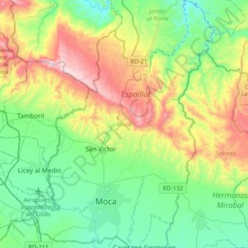
Name: Moca topographic map, elevation, terrain.
Location: Moca, Espaillat, Dominican Republic (19.34408 -70.61068 19.61185 -70.40157)
Average elevation: 1,198 ft
Minimum elevation: 210 ft
Maximum elevation: 3,465 ft
Make a donation
Gear up for your next adventure:
As an Amazon Associate, this site earns from qualifying purchases at no extra cost to you.
Other topographic maps
Click on a map to view its topography, its elevation and its terrain.