
Thank you for supporting this site ❤️
Make a donation
Make a donation
Gear up for your next adventure:
As an Amazon Associate, this site earns from qualifying purchases at no extra cost to you.
Lampasas topographic map
Click on the map to display elevation.
Thank you for supporting this site ❤️
Make a donation
Make a donation
Gear up for your next adventure:
As an Amazon Associate, this site earns from qualifying purchases at no extra cost to you.
About this map
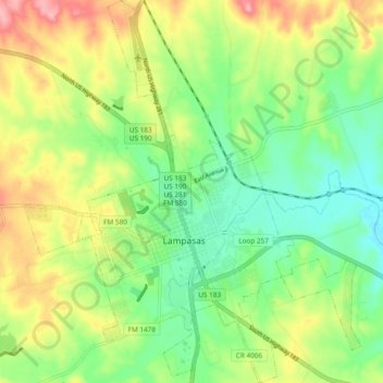
Name: Lampasas topographic map, elevation, terrain.
Location: Lampasas, Lampasas County, Texas, 76550, USA (31.03415 -98.22336 31.11538 -98.13958)
Average elevation: 1,112 ft
Minimum elevation: 961 ft
Maximum elevation: 1,335 ft
Thank you for supporting this site ❤️
Make a donation
Make a donation
Gear up for your next adventure:
As an Amazon Associate, this site earns from qualifying purchases at no extra cost to you.