
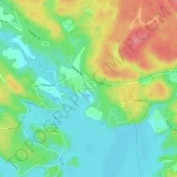
Rosseau topographic map
Interactive map
Click on the map to display elevation.
About this map
Name: Rosseau topographic map, elevation, terrain.
Average elevation: 843 ft
Minimum elevation: 728 ft
Maximum elevation: 1,040 ft
Other topographic maps
Click on a map to view its topography, its elevation and its terrain.
Otter Lake
Canada > Ontario > Parry Sound District > Seguin Township
Otter Lake, Seguin Township, Parry Sound District, Central Ontario, Ontario, Canada
Average elevation: 745 ft
Humphrey
Canada > Ontario > Parry Sound District > Seguin Township
Humphrey, Seguin Township, Parry Sound District, Central Ontario, Ontario, Canada
Average elevation: 837 ft
Salmon Lake
Canada > Ontario > Parry Sound District > Seguin Township
Salmon Lake, Seguin Township, Parry Sound District, Central Ontario, Ontario, Canada
Average elevation: 722 ft
Orrville
Canada > Ontario > Parry Sound District > Seguin Township > Orrville
Orrville, Seguin Township, Parry Sound District, Central Ontario, Ontario, Canada
Average elevation: 860 ft
Hoben Lake
Canada > Ontario > Parry Sound District > Seguin Township
Hoben Lake, Seguin Township, Parry Sound District, Central Ontario, Ontario, Canada
Average elevation: 817 ft
Seeley Bay
Canada > Ontario > Parry Sound District > Seguin Township
Seeley Bay, Seguin Township, Parry Sound District, Central Ontario, Ontario, Canada
Average elevation: 781 ft
Clear Lake
Canada > Ontario > Parry Sound District > Seguin Township
Clear Lake, Seguin Township, Parry Sound District, Central Ontario, Ontario, Canada
Average elevation: 827 ft