
Make a donation
Gear up for your next adventure:
As an Amazon Associate, this site earns from qualifying purchases at no extra cost to you.
Rafter topographic map
Click on the map to display elevation.
Make a donation
Gear up for your next adventure:
As an Amazon Associate, this site earns from qualifying purchases at no extra cost to you.
About this map
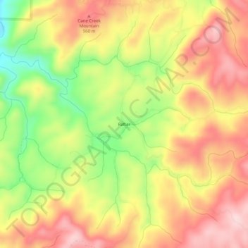
Name: Rafter topographic map, elevation, terrain.
Location: Rafter, Monroe County, Tennessee, United States (35.37258 -84.19825 35.41258 -84.15825)
Average elevation: 1,549 ft
Minimum elevation: 1,024 ft
Maximum elevation: 1,952 ft
Make a donation
Gear up for your next adventure:
As an Amazon Associate, this site earns from qualifying purchases at no extra cost to you.
Other topographic maps
Click on a map to view its topography, its elevation and its terrain.
Make a donation
Gear up for your next adventure:
As an Amazon Associate, this site earns from qualifying purchases at no extra cost to you.
Bald River Gorge Wilderness
United States > Tennessee > Monroe County
Bald River Gorge Wilderness is a 3,721-acre (15 km2) wilderness area of Cherokee National Forest that lies within Monroe County in the U.S. state of Tennessee, designated in 1984. Its elevation is 2,642 feet (805 m) above sea level. It is administered by the United States Forest Service.
Average elevation: 2,093 ft
Make a donation
Gear up for your next adventure:
As an Amazon Associate, this site earns from qualifying purchases at no extra cost to you.
Make a donation
Gear up for your next adventure:
As an Amazon Associate, this site earns from qualifying purchases at no extra cost to you.