
Devils Lake topographic map
Click on the map to display elevation.
Devils Lake
The first post office was founded November 15, 1882, and was originally named Creelsburg. It was founded by Lieutenant Heber M. Creel, a West Point graduate and topographical engineer stationed at nearby Fort Totten. After resigning from the U.S. Army, he surveyed the land and established the townsite.
About this map
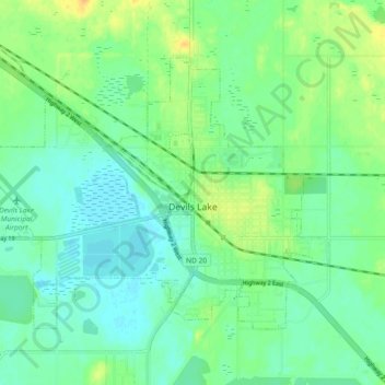
Name: Devils Lake topographic map, elevation, terrain.
Location: Devils Lake, Ramsey County, North Dakota, United States (48.08578 -98.91935 48.14050 -98.83274)
Average elevation: 1,450 ft
Minimum elevation: 1,421 ft
Maximum elevation: 1,506 ft
Ramsey County trails, hiking, mountain biking, running and outdoor activities