
Saint Augustine topographic map
Interactive map
Click on the map to display elevation.
About this map
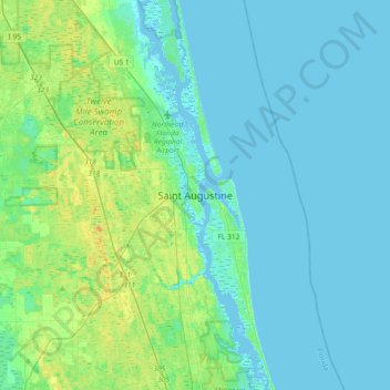
Name: Saint Augustine topographic map, elevation, terrain.
Average elevation: 16 ft
Minimum elevation: -16 ft
Maximum elevation: 69 ft
Saint Johns County trails, hiking, mountain biking, running and outdoor activities
Other topographic maps
Click on a map to view its topography, its elevation and its terrain.
Julington Creek Plantation Park
United States > Florida > Saint Johns County > Fruit Cove
Average elevation: 23 ft
Castillo de San Marcos
United States > Florida > Saint Johns County > Saint Augustine
Average elevation: 7 ft
Twelve Mile Swamp Conservation Area
United States > Florida > Saint Johns County
Average elevation: 26 ft