
Thank you for supporting this site ❤️
Make a donation
Make a donation
Gear up for your next adventure:
As an Amazon Associate, this site earns from qualifying purchases at no extra cost to you.
恒丰乡 topographic map
Click on the map to display elevation.
Thank you for supporting this site ❤️
Make a donation
Make a donation
Gear up for your next adventure:
As an Amazon Associate, this site earns from qualifying purchases at no extra cost to you.
About this map
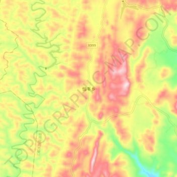
Name: 恒丰乡 topographic map, elevation, terrain.
Location: 恒丰乡, 三都水族自治县, Qiannan, Guizhou, 558000, China (25.60097 107.78985 25.68097 107.86985)
Average elevation: 2,910 ft
Minimum elevation: 2,116 ft
Maximum elevation: 3,599 ft
Thank you for supporting this site ❤️
Make a donation
Make a donation
Gear up for your next adventure:
As an Amazon Associate, this site earns from qualifying purchases at no extra cost to you.