
Thank you for supporting this site ❤️
Make a donation
Make a donation
Gear up for your next adventure:
As an Amazon Associate, this site earns from qualifying purchases at no extra cost to you.
Paltinis topographic map
Click on the map to display elevation.
Thank you for supporting this site ❤️
Make a donation
Make a donation
Gear up for your next adventure:
As an Amazon Associate, this site earns from qualifying purchases at no extra cost to you.
About this map
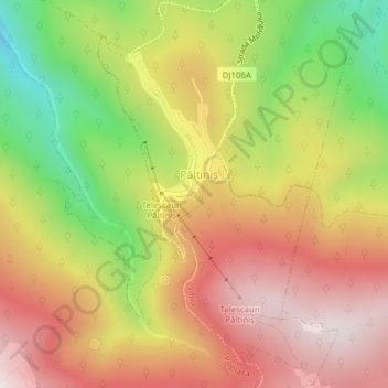
Name: Paltinis topographic map, elevation, terrain.
Location: Paltinis, Strada Oncești, Păltiniș, Sibiu, 550001, Romania (45.65158 23.93143 45.65168 23.93153)
Average elevation: 4,656 ft
Minimum elevation: 3,504 ft
Maximum elevation: 5,577 ft
Thank you for supporting this site ❤️
Make a donation
Make a donation
Gear up for your next adventure:
As an Amazon Associate, this site earns from qualifying purchases at no extra cost to you.