Geolocate

Longstone topographic map

Click on the map to display elevation.

About this map

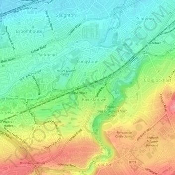
Name: Longstone topographic map, elevation, terrain.

Location: Longstone, City of Edinburgh, Scotland, United Kingdom (55.91177 -3.27274 55.92643 -3.24796)

Average elevation: 279 ft

Minimum elevation: 154 ft

Maximum elevation: 463 ft

Other topographic maps

Click on a map to view its topography, its elevation and its terrain.

Ratho

United Kingdom > Scotland > City of Edinburgh

Average elevation: 262 ft

Hillend

United Kingdom > Scotland > City of Edinburgh > Ratho

Average elevation: 220 ft

Gogar

United Kingdom > Scotland > City of Edinburgh

Average elevation: 167 ft

Newbridge

United Kingdom > Scotland > City of Edinburgh

Average elevation: 177 ft

Calton Hill

United Kingdom > Scotland > City of Edinburgh

Average elevation: 177 ft

Crow Hill

United Kingdom > Scotland > City of Edinburgh

Average elevation: 223 ft

Calton Hill

United Kingdom > Scotland > City of Edinburgh

Average elevation: 177 ft

Castle Rock

United Kingdom > Scotland > City of Edinburgh

Average elevation: 217 ft

The Meadows

United Kingdom > Scotland > City of Edinburgh

Average elevation: 256 ft

Gogarbank

United Kingdom > Scotland > City of Edinburgh

Average elevation: 226 ft

Calton Hill

United Kingdom > Scotland > City of Edinburgh

Average elevation: 177 ft

Hillend

United Kingdom > Scotland > City of Edinburgh > Ratho

Average elevation: 220 ft

Gear up for your next adventure:

🔪Outdoor Multitools - Essential survival tools for gear repair and field use
🧣Merino Neck Gaiters - Multi-functional headwear for wind and sun protection
🧷Carabiner Set - Durable clips for gear attachment
👖Convertible Hiking Pants - Versatile zip-off pants for changing altitudes and temperatures
🦶Hiking Gaiters - Keep debris and water out of your boots

As an Amazon Associate, this site earns from qualifying purchases at no extra cost to you.