Geolocate

Lindale topographic map

Click on the map to display elevation.

About this map

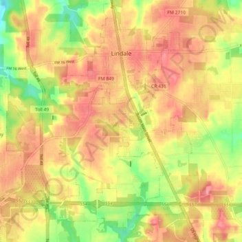
Name: Lindale topographic map, elevation, terrain.

Location: Lindale, Smith County, Texas, 75771, United States (32.45668 -95.45790 32.53230 -95.38082)

Average elevation: 515 ft

Minimum elevation: 358 ft

Maximum elevation: 614 ft

Smith County trails, hiking, mountain biking, running and outdoor activities

Other topographic maps

Click on a map to view its topography, its elevation and its terrain.

Thedford

United States > Texas > Smith County > Lindale

Average elevation: 509 ft

Swan

United States > Texas > Smith County

Average elevation: 512 ft

Fun Forest Park

United States > Texas > Smith County > Tyler

Average elevation: 535 ft

Owentown

United States > Texas > Smith County

Average elevation: 397 ft

Whitehouse

United States > Texas > Smith County

Average elevation: 466 ft

Tyler

United States > Texas > Smith County > Tyler

Average elevation: 466 ft

Pine Springs

United States > Texas > Smith County > Tyler > Pine Springs

Average elevation: 509 ft

Tyler

United States > Texas > Smith County

Average elevation: 482 ft

Gear up for your next adventure:

📦Gear Storage Bags - Organize and protect outdoor equipment
🧤Hiking Gloves - Protective gloves for rugged trails
🥇GPS Hiking Watch - Multi‑sport GPS watch with navigation and trail tracking
🔥Camping Stove - Portable stove for camping and backcountry cooking
🦟Ultrasonic Repellers - Create a bug-free zone at your camp or rest stop

As an Amazon Associate, this site earns from qualifying purchases at no extra cost to you.