Geolocate

Graham topographic map

Click on the map to display elevation.

About this map

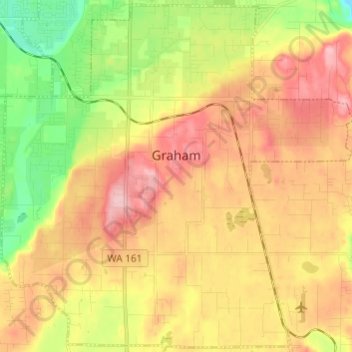
Name: Graham topographic map, elevation, terrain.

Location: Graham, Pierce County, Washington, United States (46.98000 -122.36776 47.09643 -122.19882)

Average elevation: 597 ft

Minimum elevation: 161 ft

Maximum elevation: 1,158 ft

Pierce County trails, hiking, mountain biking, running and outdoor activities

Gear up for your next adventure:

📚Navigation Handbooks - Master the art of reading topographic maps and using a compass
🌎3D Topographic Globes - Raised relief globes for a tactile understanding of geography
🧣Hiking Neck Gaiter - Multi‑use neck protection for outdoor weather
🪶Trail Camera - Capture wildlife on your hikes
🧢Sun Protection Hats - Wide-brimmed and UPF-rated hats for high-altitude sun safety

As an Amazon Associate, this site earns from qualifying purchases at no extra cost to you.