
Thank you for supporting this site ❤️
Make a donation
Make a donation
Gear up for your next adventure:
As an Amazon Associate, this site earns from qualifying purchases at no extra cost to you.
Khula Kangri I topographic map
Click on the map to display elevation.
Thank you for supporting this site ❤️
Make a donation
Make a donation
Gear up for your next adventure:
As an Amazon Associate, this site earns from qualifying purchases at no extra cost to you.
About this map
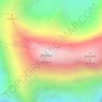
Name: Khula Kangri I topographic map, elevation, terrain.
Location: Khula Kangri I, Se, Lhodrak County, Lhoka, Tibet, China (28.22726 90.61521 28.22736 90.61531)
Average elevation: 21,529 ft
Minimum elevation: 18,812 ft
Maximum elevation: 24,741 ft
Thank you for supporting this site ❤️
Make a donation
Make a donation
Gear up for your next adventure:
As an Amazon Associate, this site earns from qualifying purchases at no extra cost to you.