
Make a donation
Gear up for your next adventure:
As an Amazon Associate, this site earns from qualifying purchases at no extra cost to you.
Burlington topographic map
Click on the map to display elevation.
Make a donation
Gear up for your next adventure:
As an Amazon Associate, this site earns from qualifying purchases at no extra cost to you.
About this map
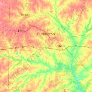
Name: Burlington topographic map, elevation, terrain.
Location: Burlington, Alamance County, North Carolina, United States (36.00971 -79.62141 36.12776 -79.37193)
Average elevation: 610 ft
Minimum elevation: 446 ft
Maximum elevation: 761 ft
Alamance County trails, hiking, mountain biking, running and outdoor activities
Make a donation
Gear up for your next adventure:
As an Amazon Associate, this site earns from qualifying purchases at no extra cost to you.
Other topographic maps
Click on a map to view its topography, its elevation and its terrain.
Wedgewood West
United States > North Carolina > Alamance County > Burlington
Average elevation: 666 ft
Country Club Estates
United States > North Carolina > Alamance County > Burlington
Average elevation: 640 ft
Make a donation
Gear up for your next adventure:
As an Amazon Associate, this site earns from qualifying purchases at no extra cost to you.
Make a donation
Gear up for your next adventure:
As an Amazon Associate, this site earns from qualifying purchases at no extra cost to you.