
Lee topographic map
Interactive map
Click on the map to display elevation.
About this map
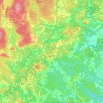
Name: Lee topographic map, elevation, terrain.
Location: Lee, Strafford County, New Hampshire, 03861, United States (43.08162 -71.07310 43.17240 -70.96073)
Average elevation: 154 ft
Minimum elevation: 20 ft
Maximum elevation: 384 ft
Other topographic maps
Click on a map to view its topography, its elevation and its terrain.
Rollinsford
United States > New Hampshire > Strafford County
Rollinsford, Strafford County, New Hampshire, 03869, United States
Average elevation: 105 ft
Somersworth
United States > New Hampshire > Strafford County
Somersworth, Strafford County, New Hampshire, 03878, United States
Average elevation: 184 ft
New Durham
United States > New Hampshire > Strafford County
New Durham, Strafford County, New Hampshire, 03855, United States
Average elevation: 748 ft
Dover
United States > New Hampshire > Strafford County
Dover, Strafford County, New Hampshire, 03820, United States
Average elevation: 102 ft
Dover
United States > New Hampshire > Strafford County > Dover
Dover, Strafford County, New Hampshire, 03820, United States
Average elevation: 171 ft
Rochester
United States > New Hampshire > Strafford County > Rochester
Rochester, Strafford County, New Hampshire, United States
Average elevation: 295 ft