
Make a donation
Gear up for your next adventure:
As an Amazon Associate, this site earns from qualifying purchases at no extra cost to you.
Gustorf topographic map
Click on the map to display elevation.
Make a donation
Gear up for your next adventure:
As an Amazon Associate, this site earns from qualifying purchases at no extra cost to you.
Gustorf
Auf der Gustorfer Höhe befindet sich ein Segelflugplatz. Der Radweg Energiepfad Grevenbroich verläuft auch durch das Gemeindegebiet. Der Bürgerschützenverein Gustorf wurde Im Jahr 1862 gegründet, er veranstaltet einen jährlichen Fackelumzug.
Make a donation
Gear up for your next adventure:
As an Amazon Associate, this site earns from qualifying purchases at no extra cost to you.
About this map
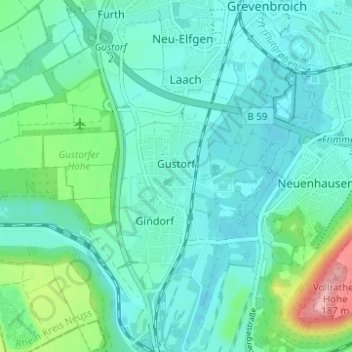
Name: Gustorf topographic map, elevation, terrain.
Average elevation: 236 ft
Minimum elevation: 148 ft
Maximum elevation: 607 ft
Make a donation
Gear up for your next adventure:
As an Amazon Associate, this site earns from qualifying purchases at no extra cost to you.
Other topographic maps
Click on a map to view its topography, its elevation and its terrain.