
Village of Vernon topographic map
Interactive map
Click on the map to display elevation.
About this map
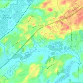
Name: Village of Vernon topographic map, elevation, terrain.
Location: Village of Vernon, Waukesha County, Wisconsin, United States (42.84195 -88.30652 42.93020 -88.18827)
Average elevation: 843 ft
Minimum elevation: 764 ft
Maximum elevation: 1,024 ft
Waukesha County trails, hiking, mountain biking, running and outdoor activities
Other topographic maps
Click on a map to view its topography, its elevation and its terrain.
Menomonee Falls
United States > Wisconsin > Waukesha County > Menomonee Falls
Average elevation: 853 ft