Geolocate

Marilog topographic map

Click on the map to display elevation.

About this map

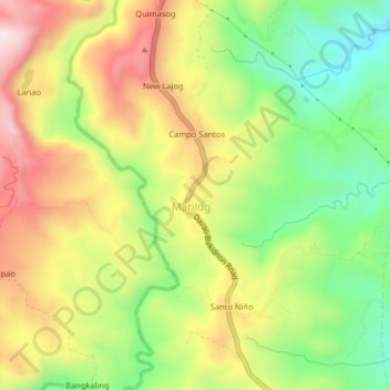
Name: Marilog topographic map, elevation, terrain.

Location: Marilog, Davao City, Davao Region, Philippines (7.27748 125.28301 7.31748 125.32301)

Average elevation: 1,745 ft

Minimum elevation: 968 ft

Maximum elevation: 2,618 ft

Other topographic maps

Click on a map to view its topography, its elevation and its terrain.

Tamugan River

Philippines > Davao City > Marilog

Average elevation: 1,145 ft

Gear up for your next adventure:

💧Water Filtration Bottles - Safely drink from streams and lakes while exploring
🛏️Cold Weather Sleeping Bag - Warm sleeping bag for cold conditions
👟Men's Trail Runners - Lightweight footwear for fast-paced exploration and light hiking
🔭Telescopic Hiking Pole - Adjustable pole for hiking stability
🎒Gear Packing Cubes - Organize your backpack efficiently

As an Amazon Associate, this site earns from qualifying purchases at no extra cost to you.