Geolocate

Basag topographic map

Click on the map to display elevation.

About this map

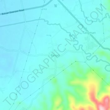
Name: Basag topographic map, elevation, terrain.

Location: Basag, Butuan, Caraga, Philippines (8.91258 125.59652 8.95258 125.63652)

Average elevation: 138 ft

Minimum elevation: 33 ft

Maximum elevation: 741 ft

Gear up for your next adventure:

🛰️Handheld GPS Units - Professional satellite navigators for precise backcountry mapping
👟Trail Running Shoes - Lightweight shoes for trail runners
🍳Camping Cook Set - Complete cookware for outdoor meals
📖Nature Tracking Books - Learn to track wildlife and terrain
🧣Merino Neck Gaiters - Multi-functional headwear for wind and sun protection

As an Amazon Associate, this site earns from qualifying purchases at no extra cost to you.