
Make a donation
Gear up for your next adventure:
As an Amazon Associate, this site earns from qualifying purchases at no extra cost to you.
Islands District topographic map
Click on the map to display elevation.
Make a donation
Gear up for your next adventure:
As an Amazon Associate, this site earns from qualifying purchases at no extra cost to you.
About this map
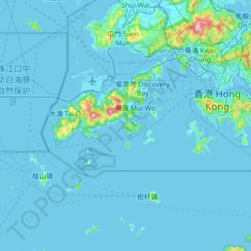
Name: Islands District topographic map, elevation, terrain.
Location: Islands District, New Territories, Hong Kong, China (22.13672 113.81724 22.32463 114.30923)
Average elevation: 118 ft
Minimum elevation: -33 ft
Maximum elevation: 3,077 ft
Make a donation
Gear up for your next adventure:
As an Amazon Associate, this site earns from qualifying purchases at no extra cost to you.
Other topographic maps
Click on a map to view its topography, its elevation and its terrain.
Victoria Peak
China > Hong Kong > Hong Kong Island
Victoria Peak is a hill on the western half of Hong Kong Island. It is also known as Mount Austin, and locally as The Peak. With an elevation of 552 metres (1,811 ft), it is the highest hill in Hong Kong island, ranked 29 in terms of elevation in Hong Kong (Tai Mo Shan is the highest point in Hong Kong with an…
Average elevation: 686 ft
Make a donation
Gear up for your next adventure:
As an Amazon Associate, this site earns from qualifying purchases at no extra cost to you.