
Thank you for supporting this site ❤️
Make a donation
Make a donation
Gear up for your next adventure:
As an Amazon Associate, this site earns from qualifying purchases at no extra cost to you.
Zanjan topographic map
Click on the map to display elevation.
Thank you for supporting this site ❤️
Make a donation
Make a donation
Gear up for your next adventure:
As an Amazon Associate, this site earns from qualifying purchases at no extra cost to you.
About this map
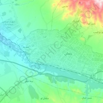
Name: Zanjan topographic map, elevation, terrain.
Location: Zanjan, بخش مرکزی, Zanjan County, Zanjan Province, Iran (36.63784 48.43041 36.72493 48.60262)
Average elevation: 5,840 ft
Minimum elevation: 5,138 ft
Maximum elevation: 8,232 ft
Thank you for supporting this site ❤️
Make a donation
Make a donation
Gear up for your next adventure:
As an Amazon Associate, this site earns from qualifying purchases at no extra cost to you.