Geolocate

Tomset topographic map

Click on the map to display elevation.

About this map

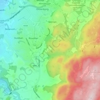
Name: Tomset topographic map, elevation, terrain.

Location: Tomset, Lerkendal, Trondheim, Trøndelag, 7036, Norway (63.37016 10.42444 63.41016 10.46444)

Average elevation: 554 ft

Minimum elevation: 85 ft

Maximum elevation: 1,388 ft

Gear up for your next adventure:

🪵Folding Camp Saw - Compact saw for wood and campsite work
🪶Paracord Bracelet - Survival bracelet with built‑in tools
📌Outdoor GPS Map App - Apps and devices for digital topographic navigation
🧭Map Reading Tools - Tools and kits for map navigation
💧Water Filtration Bottles - Safely drink from streams and lakes while exploring

As an Amazon Associate, this site earns from qualifying purchases at no extra cost to you.