
Make a donation
Gear up for your next adventure:
As an Amazon Associate, this site earns from qualifying purchases at no extra cost to you.
Großhöhfeld topographic map
Click on the map to display elevation.
Make a donation
Gear up for your next adventure:
As an Amazon Associate, this site earns from qualifying purchases at no extra cost to you.
Großhöhfeld
1481 wird der Ort erstmals unter der Bezeichnung „Hoyfeld“ in einer Spendenliste für den Marienaltar der Hückeswagener Kirche aufgeführt. Die Karte Topographia Ducatus Montani aus dem Jahre 1715 zeigt einen Hof und bezeichnet diesen mit „gr. Hoefeld“.
Make a donation
Gear up for your next adventure:
As an Amazon Associate, this site earns from qualifying purchases at no extra cost to you.
About this map
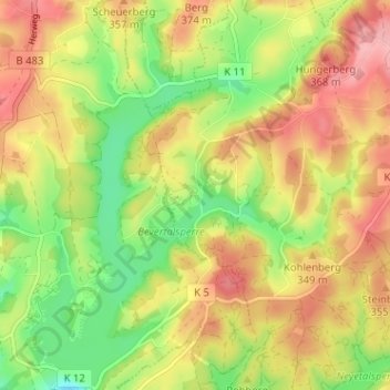
Name: Großhöhfeld topographic map, elevation, terrain.
Average elevation: 1,079 ft
Minimum elevation: 883 ft
Maximum elevation: 1,260 ft
Make a donation
Gear up for your next adventure:
As an Amazon Associate, this site earns from qualifying purchases at no extra cost to you.
Other topographic maps
Click on a map to view its topography, its elevation and its terrain.
51688
Deutschland > Nordrhein-Westfalen > Oberbergischer Kreis > Wipperfürth > Lendringhausen
Average elevation: 1,056 ft
Neyetalsperre
Deutschland > Nordrhein-Westfalen > Oberbergischer Kreis > Wipperfürth > Hönnige
Average elevation: 1,076 ft