Geolocate

Reutern topographic map

Click on the map to display elevation.

About this map

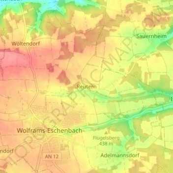
Name: Reutern topographic map, elevation, terrain.

Location: Reutern, Wolframs-Eschenbach, Wolframs-Eschenbach (VGem), Landkreis Ansbach, Bayern, 91639, Deutschland (49.21681 10.71840 49.25681 10.75840)

Average elevation: 1,447 ft

Minimum elevation: 1,293 ft

Maximum elevation: 1,542 ft

Other topographic maps

Click on a map to view its topography, its elevation and its terrain.

Gear up for your next adventure:

📌Outdoor GPS Map App - Apps and devices for digital topographic navigation
🛠️Backpacking Tool Kit - Essential toolkit for outdoor repairs
🪵Folding Camp Saw - Compact saw for wood and campsite work
🧤Hiking Gloves - Protective gloves for rugged trails
🦶Carbon Trekking Poles - Reduce knee impact on steep descents with ultra-light poles

As an Amazon Associate, this site earns from qualifying purchases at no extra cost to you.