
Make a donation
Gear up for your next adventure:
As an Amazon Associate, this site earns from qualifying purchases at no extra cost to you.
Vallestretta topographic map
Click on the map to display elevation.
Make a donation
Gear up for your next adventure:
As an Amazon Associate, this site earns from qualifying purchases at no extra cost to you.
Vallestretta
La frazione è situata nella parte terminale di una valle lunga e stretta (da cui il nome), ad un'altitudine compresa tra gli 800 ed i 900 metri s.l.m., ed è divisa in due agglomerati: Tresto, destra orografica della valle; Di Cuntra, sinistra orografica.
Make a donation
Gear up for your next adventure:
As an Amazon Associate, this site earns from qualifying purchases at no extra cost to you.
About this map
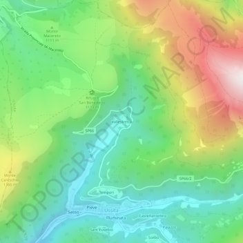
Name: Vallestretta topographic map, elevation, terrain.
Location: Vallestretta, Ussita, Macerata, 62039, Italia (42.93830 13.12021 42.97830 13.16021)
Average elevation: 3,622 ft
Minimum elevation: 2,231 ft
Maximum elevation: 6,188 ft
Make a donation
Gear up for your next adventure:
As an Amazon Associate, this site earns from qualifying purchases at no extra cost to you.