
Make a donation
Gear up for your next adventure:
As an Amazon Associate, this site earns from qualifying purchases at no extra cost to you.
Castro Valley topographic map
Click on the map to display elevation.
Make a donation
Gear up for your next adventure:
As an Amazon Associate, this site earns from qualifying purchases at no extra cost to you.
About this map
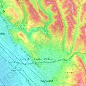
Name: Castro Valley topographic map, elevation, terrain.
Location: Castro Valley, Alameda County, California, United States (37.67438 -122.13113 37.75269 -122.00223)
Average elevation: 394 ft
Minimum elevation: -3 ft
Maximum elevation: 1,181 ft
Alameda County trails, hiking, mountain biking, running and outdoor activities
Make a donation
Gear up for your next adventure:
As an Amazon Associate, this site earns from qualifying purchases at no extra cost to you.
Other topographic maps
Click on a map to view its topography, its elevation and its terrain.
Lake Chabot - Main Entrance
United States > California > Alameda County > Castro Valley
Average elevation: 358 ft