Geolocate

Merilla topographic map

Click on the map to display elevation.

About this map

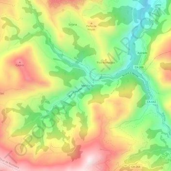
Name: Merilla topographic map, elevation, terrain.

Location: Merilla, San Roque de Riomiera, Cantabria, 39728, Spain (43.23274 -3.75034 43.27274 -3.71034)

Average elevation: 1,762 ft

Minimum elevation: 771 ft

Maximum elevation: 2,851 ft

Gear up for your next adventure:

🎒Trekking Poles - Sturdy poles for balance and stability on rough terrain
🧢Sun Protection Hats - Wide-brimmed and UPF-rated hats for high-altitude sun safety
🏫Relief Map Kits - Hands-on tools for teaching landforms and elevation
🧢Outdoor Hiking Hat - Sun protection hat for outdoor explorers
🧦Merino Wool Socks - Moisture-wicking, blister-preventing socks for long treks

As an Amazon Associate, this site earns from qualifying purchases at no extra cost to you.