Geolocate

Piatto topographic map

Click on the map to display elevation.

About this map

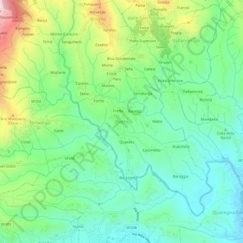
Name: Piatto topographic map, elevation, terrain.

Location: Piatto, Biella, Piemonte, Italia (45.56986 8.11532 45.60986 8.15532)

Average elevation: 1,253 ft

Minimum elevation: 830 ft

Maximum elevation: 2,178 ft

Other topographic maps

Click on a map to view its topography, its elevation and its terrain.

Viverone

Italia > Piemonte > Biella

Average elevation: 974 ft

Gifflenga

Italia > Piemonte > Biella

Average elevation: 617 ft

Candelo

Italia > Piemonte > Biella

Average elevation: 1,007 ft

Ponderano

Italia > Piemonte > Biella

Average elevation: 1,119 ft

Torrazzo

Italia > Piemonte > Biella

Average elevation: 1,765 ft

Trivero

Italia > Piemonte > Biella

Average elevation: 3,419 ft

Sandigliano

Italia > Piemonte > Biella > Sandigliano

Average elevation: 1,007 ft

Gear up for your next adventure:

🗺️NatGeo Topo Maps - High-quality waterproof printed topographic maps of US Parks
🌐World Map Poster - Decorative world maps with topographic info
🧺Microfiber Travel Towels - Compact and fast-drying towels for trail use
🥇GPS Hiking Watch - Multi‑sport GPS watch with navigation and trail tracking
🔪Outdoor Multitools - Essential survival tools for gear repair and field use

As an Amazon Associate, this site earns from qualifying purchases at no extra cost to you.