
Make a donation
Gear up for your next adventure:
As an Amazon Associate, this site earns from qualifying purchases at no extra cost to you.
Zacatal topographic map
Click on the map to display elevation.
Make a donation
Gear up for your next adventure:
As an Amazon Associate, this site earns from qualifying purchases at no extra cost to you.
About this map
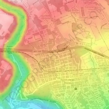
Name: Zacatal topographic map, elevation, terrain.
Location: Zacatal, Fortín de las Flores, Veracruz, México (18.90525 -97.00254 18.90661 -97.00080)
Average elevation: 3,323 ft
Minimum elevation: 2,871 ft
Maximum elevation: 3,566 ft
Make a donation
Gear up for your next adventure:
As an Amazon Associate, this site earns from qualifying purchases at no extra cost to you.
Other topographic maps
Click on a map to view its topography, its elevation and its terrain.
Camino a Villa Unión
México > Veracruz > Fortín de las Flores > Fortín de las Flores
Average elevation: 3,189 ft
Santa Lucía Potrerillo
México > Veracruz > Fortín de las Flores > Monte Blanco
Average elevation: 4,157 ft
Make a donation
Gear up for your next adventure:
As an Amazon Associate, this site earns from qualifying purchases at no extra cost to you.
San José
México > Veracruz > Fortín de las Flores > Fortín de las Flores > San José
Average elevation: 3,553 ft