
Make a donation
Gear up for your next adventure:
As an Amazon Associate, this site earns from qualifying purchases at no extra cost to you.
Bonlez topographic map
Click on the map to display elevation.
Make a donation
Gear up for your next adventure:
As an Amazon Associate, this site earns from qualifying purchases at no extra cost to you.
About this map
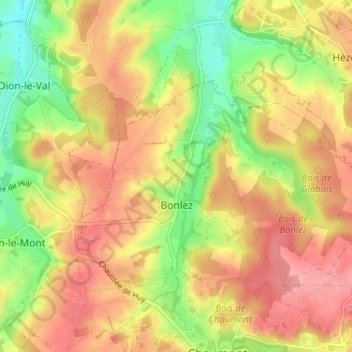
Name: Bonlez topographic map, elevation, terrain.
Average elevation: 318 ft
Minimum elevation: 141 ft
Maximum elevation: 456 ft
Make a donation
Gear up for your next adventure:
As an Amazon Associate, this site earns from qualifying purchases at no extra cost to you.
Other topographic maps
Click on a map to view its topography, its elevation and its terrain.
Make a donation
Gear up for your next adventure:
As an Amazon Associate, this site earns from qualifying purchases at no extra cost to you.
Make a donation
Gear up for your next adventure:
As an Amazon Associate, this site earns from qualifying purchases at no extra cost to you.
Bonly
Belgique > Brabant wallon > Nivelles > Chaumont-Gistoux > Dion-le-Mont
Average elevation: 312 ft
El Pirère
Belgique > Brabant wallon > Nivelles > Chaumont-Gistoux > El Pirère
Average elevation: 364 ft
Make a donation
Gear up for your next adventure:
As an Amazon Associate, this site earns from qualifying purchases at no extra cost to you.
Grippelotte
Belgique > Brabant wallon > Nivelles > Chaumont-Gistoux > Dion-le-Mont
Average elevation: 338 ft