
Thank you for supporting this site ❤️
Make a donation
Make a donation
Gear up for your next adventure:
As an Amazon Associate, this site earns from qualifying purchases at no extra cost to you.
Buga topographic map
Click on the map to display elevation.
Thank you for supporting this site ❤️
Make a donation
Make a donation
Gear up for your next adventure:
As an Amazon Associate, this site earns from qualifying purchases at no extra cost to you.
About this map
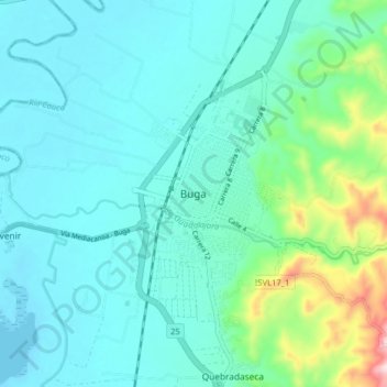
Name: Buga topographic map, elevation, terrain.
Location: Buga, Centro, Valle del Cauca, 762001, Colombia (3.86006 -76.34201 3.94006 -76.26201)
Average elevation: 3,278 ft
Minimum elevation: 3,025 ft
Maximum elevation: 4,472 ft
Thank you for supporting this site ❤️
Make a donation
Make a donation
Gear up for your next adventure:
As an Amazon Associate, this site earns from qualifying purchases at no extra cost to you.