
Matadi topographic map
Interactive map
Click on the map to display elevation.
About this map
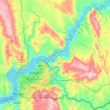
Name: Matadi topographic map, elevation, terrain.
Location: Matadi, Kongo Central, Democratic Republic of the Congo (-5.88652 13.41169 -5.70628 13.58709)
Average elevation: 719 ft
Minimum elevation: -36 ft
Maximum elevation: 1,785 ft
Other topographic maps
Click on a map to view its topography, its elevation and its terrain.
Mont Amba
Democratic Republic of the Congo > Kongo Central
Mont Amba, Kongo Central, Democratic Republic of the Congo
Average elevation: 1,178 ft