
Thank you for supporting this site ❤️
Make a donation
Make a donation
Gear up for your next adventure:
As an Amazon Associate, this site earns from qualifying purchases at no extra cost to you.
Radio topographic map
Click on the map to display elevation.
Thank you for supporting this site ❤️
Make a donation
Make a donation
Gear up for your next adventure:
As an Amazon Associate, this site earns from qualifying purchases at no extra cost to you.
About this map
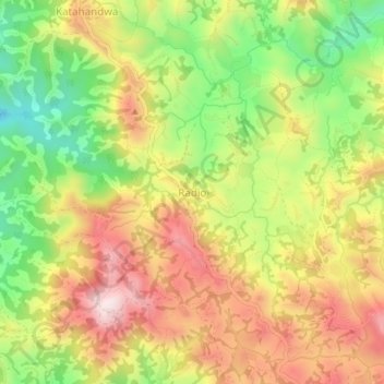
Name: Radio topographic map, elevation, terrain.
Location: Radio, Masisi, North Kivu, Democratic Republic of the Congo (-1.49465 28.70888 -1.45465 28.74888)
Average elevation: 6,168 ft
Minimum elevation: 5,361 ft
Maximum elevation: 6,939 ft
Thank you for supporting this site ❤️
Make a donation
Make a donation
Gear up for your next adventure:
As an Amazon Associate, this site earns from qualifying purchases at no extra cost to you.