Geolocate

Al-Turah topographic map

Click on the map to display elevation.

About this map

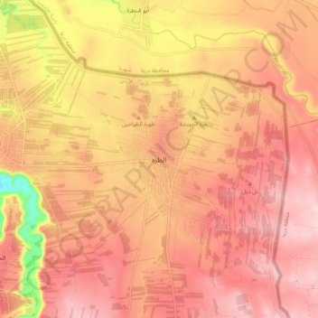
Name: Al-Turah topographic map, elevation, terrain.

Location: Al-Turah, Ramtha Sub-District, Ramtha District, Irbid, Jordan (32.59943 35.94951 32.67943 36.02951)

Average elevation: 1,512 ft

Minimum elevation: 971 ft

Maximum elevation: 1,759 ft

Gear up for your next adventure:

📦Dry Bags Set - Waterproof storage for electronics and clothes
🧺Microfiber Travel Towels - Compact and fast-drying towels for trail use
🛡️Bear Spray Outdoor - Protection in bear country hikes
🪶Trail Camera - Capture wildlife on your hikes
🪶Multi‑Purpose Knife - Useful blade for camp and trail

As an Amazon Associate, this site earns from qualifying purchases at no extra cost to you.