Make a donation
Gear up for your next adventure:
As an Amazon Associate, this site earns from qualifying purchases at no extra cost to you.
涟湖 topographic map
Click on the map to display elevation.
Make a donation
Gear up for your next adventure:
As an Amazon Associate, this site earns from qualifying purchases at no extra cost to you.
About this map
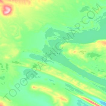
Name: 涟湖 topographic map, elevation, terrain.
Location: 涟湖, 索加乡, 治多县, 玉树藏族自治州, 青海省, 中国 (35.47811 90.13692 35.62252 90.30310)
Average elevation: 16,207 ft
Minimum elevation: 15,981 ft
Maximum elevation: 16,811 ft
Make a donation
Gear up for your next adventure:
As an Amazon Associate, this site earns from qualifying purchases at no extra cost to you.
Other topographic maps
Click on a map to view its topography, its elevation and its terrain.

可可西里
青海可可西里遗产地面积37356.32平方公里,缓冲区面积22909.04平方公里,包含4500米海拔以上高寒山区和草原系统,基本未曾受到人类活动的影响。该遗产地从西北向东南逐渐向下倾斜,昆仑山脉、可可西里山脉和乌兰乌拉山脉在此由东向西延伸达500 多公里,并在两大盆地间几乎成平行趋势,形成了当地“三山间两盆”的说法。这些湖泊盆地所构成的平坦、开阔的地势,带来了整个青藏高原保存最为完好的夷表面以及罕见的高密度的湖泊。这些湖泊展现了一系列完整的演替阶段,形成了重要的长江源头流域和以水体为主体的壮丽景观。可可西里属于寒冷的高原气候,每年平均气温在4℃到-9℃,最低温度有时达到-45℃,干湿季明显,降水集中在夏季。
Average elevation: 15,643 ft
Make a donation
Gear up for your next adventure:
As an Amazon Associate, this site earns from qualifying purchases at no extra cost to you.