Geolocate

Bonot topographic map

Click on the map to display elevation.

About this map

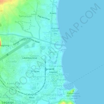
Name: Bonot topographic map, elevation, terrain.

Location: Bonot, Legazpi, Albay, Bicol Region, 4500, Philippines (13.13815 123.73185 13.17815 123.77185)

Average elevation: 23 ft

Minimum elevation: 0 ft

Maximum elevation: 171 ft

Other topographic maps

Click on a map to view its topography, its elevation and its terrain.

Peñaranda Park

Philippines > Albay > Legazpi > Baño

Average elevation: 121 ft

Gear up for your next adventure:

🪶Multi‑Purpose Knife - Useful blade for camp and trail
👟Men's Trail Runners - Lightweight footwear for fast-paced exploration and light hiking
🚗GPS Dash Cams - Record your scenic drives through mountain passes and canyons
🧢Sun Protection Hats - Wide-brimmed and UPF-rated hats for high-altitude sun safety
🌡️Handheld Weather Meters - Measure wind, temp, and pressure for safe mountain travel

As an Amazon Associate, this site earns from qualifying purchases at no extra cost to you.