
Make a donation
Gear up for your next adventure:
As an Amazon Associate, this site earns from qualifying purchases at no extra cost to you.
Inchope topographic map
Click on the map to display elevation.
Make a donation
Gear up for your next adventure:
As an Amazon Associate, this site earns from qualifying purchases at no extra cost to you.
About this map
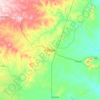
Name: Inchope topographic map, elevation, terrain.
Location: Inchope, Gondola, Manica Province, Mozambique (-19.36733 33.77293 -19.04733 34.09293)
Average elevation: 682 ft
Minimum elevation: 236 ft
Maximum elevation: 1,594 ft
Make a donation
Gear up for your next adventure:
As an Amazon Associate, this site earns from qualifying purchases at no extra cost to you.
Other topographic maps
Click on a map to view its topography, its elevation and its terrain.
Gondola
The climate of the district varies with altitude. The lowlands are characterized by relatively low rainfall, between 800 millimetres (31 in) and 1,100 millimetres (43 in). The transition zone has the average rainfall 1,200 millimetres (47 in), and in higher altitude plains it varies between 1,000 millimetres…
Average elevation: 1,109 ft