Geolocate

Riglos topographic map

Click on the map to display elevation.

About this map

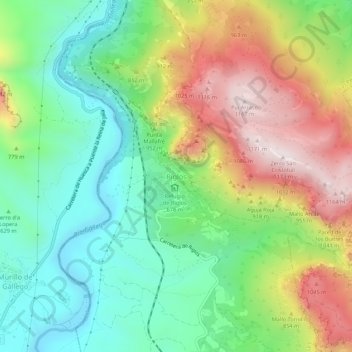
Name: Riglos topographic map, elevation, terrain.

Location: Riglos, Las Peñas de Riglos, Hoya de Huesca / Plana de Uesca, Huesca, Aragon, 22808, Spain (42.32827 -0.74673 42.36827 -0.70673)

Average elevation: 2,382 ft

Minimum elevation: 1,476 ft

Maximum elevation: 3,812 ft

Other topographic maps

Click on a map to view its topography, its elevation and its terrain.

Gear up for your next adventure:

🌐World Map Poster - Decorative world maps with topographic info
🔭Telescopic Hiking Pole - Adjustable pole for hiking stability
🪶Camp Gear Gift Set - Perfect gift bundle for outdoor fans
🦶Hiking Gaiters - Keep debris and water out of your boots
🛰️Handheld GPS Units - Professional satellite navigators for precise backcountry mapping

As an Amazon Associate, this site earns from qualifying purchases at no extra cost to you.