
Make a donation
Gear up for your next adventure:
As an Amazon Associate, this site earns from qualifying purchases at no extra cost to you.
Tyrnavos Municipality topographic map
Click on the map to display elevation.
Make a donation
Gear up for your next adventure:
As an Amazon Associate, this site earns from qualifying purchases at no extra cost to you.
About this map
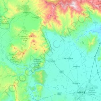
Name: Tyrnavos Municipality topographic map, elevation, terrain.
Average elevation: 974 ft
Minimum elevation: 46 ft
Maximum elevation: 4,619 ft
Make a donation
Gear up for your next adventure:
As an Amazon Associate, this site earns from qualifying purchases at no extra cost to you.
Other topographic maps
Click on a map to view its topography, its elevation and its terrain.
Νέα Μεσάγγαλα
Greece > Thessaly and Central Greece > Larisa Regional Unit > Municipal Unit of Kato Olympos
Average elevation: 0 ft
Agnanderi
Greece > Thessaly and Central Greece > Larisa Regional Unit > Municipal Unit of Kileler
Average elevation: 1,211 ft
Παραλία Κουλούρας
Greece > Thessaly and Central Greece > Larisa Regional Unit > Municipal Unit of Kato Olympos > Νέα Μεσάγγαλα
Average elevation: 0 ft
Papapouli
Greece > Thessaly and Central Greece > Larisa Regional Unit > Municipal Unit of Kato Olympos
Average elevation: 33 ft
Make a donation
Gear up for your next adventure:
As an Amazon Associate, this site earns from qualifying purchases at no extra cost to you.
(Olympus)
Greece > Thessaly and Central Greece > Larisa Regional Unit > Municipal Unit of Gonnoi
Average elevation: 3,750 ft
(Olympus)
Greece > Thessaly and Central Greece > Larisa Regional Unit > Municipal Unit of Gonnoi
Average elevation: 4,370 ft
Falani
Greece > Thessaly and Central Greece > Larisa Regional Unit > Municipal Unit of Yiannouli
Average elevation: 223 ft
Make a donation
Gear up for your next adventure:
As an Amazon Associate, this site earns from qualifying purchases at no extra cost to you.
Όλυμπος
Greece > Thessaly and Central Greece > Larisa Regional Unit > Elassona Municipality
Average elevation: 8,058 ft
Σαραντάπορο
Greece > Thessaly and Central Greece > Larisa Regional Unit > Elassona Municipality > Σαραντάπορο
Average elevation: 2,615 ft