
Make a donation
Gear up for your next adventure:
As an Amazon Associate, this site earns from qualifying purchases at no extra cost to you.
Boele topographic map
Click on the map to display elevation.
Make a donation
Gear up for your next adventure:
As an Amazon Associate, this site earns from qualifying purchases at no extra cost to you.
About this map
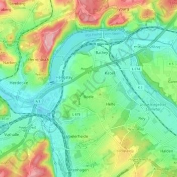
Name: Boele topographic map, elevation, terrain.
Average elevation: 466 ft
Minimum elevation: 279 ft
Maximum elevation: 846 ft
Make a donation
Gear up for your next adventure:
As an Amazon Associate, this site earns from qualifying purchases at no extra cost to you.
Other topographic maps
Click on a map to view its topography, its elevation and its terrain.
Hagen
Deutschland > Nordrhein-Westfalen > Hagen
Der Höhenunterschied vom tiefsten Punkt an der Ruhr bei Vorhalle (86 m ü. NN) zum höchsten Punkt östlich von Bölling (438 m ü. NN) 7°33'48" E, 51°17'30" N beträgt 352 m.
Average elevation: 751 ft
Make a donation
Gear up for your next adventure:
As an Amazon Associate, this site earns from qualifying purchases at no extra cost to you.