
Make a donation
Gear up for your next adventure:
As an Amazon Associate, this site earns from qualifying purchases at no extra cost to you.
Naxos topographic map
Click on the map to display elevation.
Make a donation
Gear up for your next adventure:
As an Amazon Associate, this site earns from qualifying purchases at no extra cost to you.
Naxos
Naxos experiences both a Mediterranean climate (Csa) and a hot semi-arid climate (Köppen climate classification: BSh) depending on the location. According to the stations of the National Observatory of Athens, various locations in Naxos have a hot semi-arid climate. Inland areas of the island are much wetter and cooler in winter, owing to their higher elevation.
Make a donation
Gear up for your next adventure:
As an Amazon Associate, this site earns from qualifying purchases at no extra cost to you.
About this map
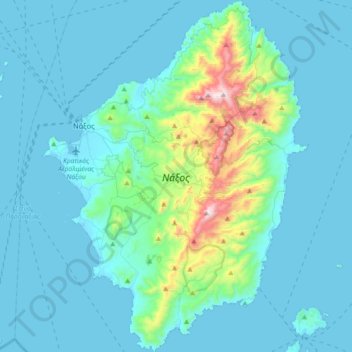
Name: Naxos topographic map, elevation, terrain.
Location: Naxos, Naxos Regional Unit, South Aegean, Aegean, Greece (36.91638 25.33292 37.20363 25.60650)
Average elevation: 367 ft
Minimum elevation: -3 ft
Maximum elevation: 3,235 ft
Make a donation
Gear up for your next adventure:
As an Amazon Associate, this site earns from qualifying purchases at no extra cost to you.