Geolocate

Valeria topographic map

Click on the map to display elevation.

About this map

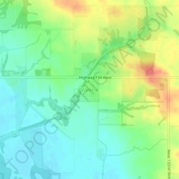
Name: Valeria topographic map, elevation, terrain.

Location: Valeria, Jasper County, Iowa, United States (41.72820 -93.32837 41.73187 -93.32341)

Average elevation: 873 ft

Minimum elevation: 794 ft

Maximum elevation: 1,010 ft

Jasper County trails, hiking, mountain biking, running and outdoor activities

Other topographic maps

Click on a map to view its topography, its elevation and its terrain.

Kellogg

United States > Iowa > Jasper County > Kellogg > Kellogg

Average elevation: 886 ft

Galesburg

United States > Iowa > Jasper County

Average elevation: 840 ft

Gear up for your next adventure:

🧭Pro Hiking Compasses - High-accuracy liquid-filled compasses for topographic orientation
Backpacking Tent - Lightweight and durable tent for multi‑day hikes
📦Dry Bags Set - Waterproof storage for electronics and clothes
🧦Hiking Socks - Comfortable socks to prevent blisters on long hikes
🦟Ultrasonic Repellers - Create a bug-free zone at your camp or rest stop

As an Amazon Associate, this site earns from qualifying purchases at no extra cost to you.