Geolocate

Tigbe topographic map

Click on the map to display elevation.

About this map

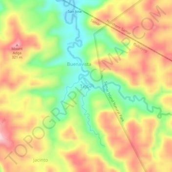
Name: Tigbe topographic map, elevation, terrain.

Location: Tigbe, Calbayog, Samar, Eastern Visayas, Philippines (12.21133 124.63856 12.25133 124.67856)

Average elevation: 640 ft

Minimum elevation: 144 ft

Maximum elevation: 1,119 ft

Other topographic maps

Click on a map to view its topography, its elevation and its terrain.

Gear up for your next adventure:

🚑Emergency Bivvies - Heat-reflective sleeping bags for survival situations
🔪Outdoor Multitools - Essential survival tools for gear repair and field use
🪶Paracord Bracelet - Survival bracelet with built‑in tools
📻Weather Alert Radios - Stay informed of storm risks while off-the-grid
🎁Geography Themed Gifts - Unique gift ideas for map lovers and geography enthusiasts

As an Amazon Associate, this site earns from qualifying purchases at no extra cost to you.