
Make a donation
Gear up for your next adventure:
As an Amazon Associate, this site earns from qualifying purchases at no extra cost to you.
Holly topographic map
Click on the map to display elevation.
Make a donation
Gear up for your next adventure:
As an Amazon Associate, this site earns from qualifying purchases at no extra cost to you.
Holly
Holly is a statutory town in Prowers County in southeastern Colorado, United States. The town is located 4.3 miles (6.9 km) west of the Kansas border at an elevation of 3,393 feet (1,034 m). Despite having the lowest elevation of any Colorado municipality, Holly is higher than the high points of 19 states and the District of Columbia. The town population was 837 at the 2020 United States Census.
Make a donation
Gear up for your next adventure:
As an Amazon Associate, this site earns from qualifying purchases at no extra cost to you.
About this map
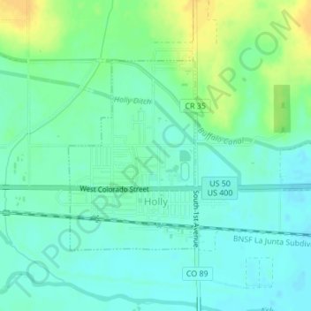
Name: Holly topographic map, elevation, terrain.
Location: Holly, Prowers County, Colorado, United States (38.04797 -102.13271 38.06447 -102.11864)
Average elevation: 3,402 ft
Minimum elevation: 3,373 ft
Maximum elevation: 3,455 ft
Prowers County trails, hiking, mountain biking, running and outdoor activities
Make a donation
Gear up for your next adventure:
As an Amazon Associate, this site earns from qualifying purchases at no extra cost to you.