
Make a donation
Gear up for your next adventure:
As an Amazon Associate, this site earns from qualifying purchases at no extra cost to you.
Klettwitz topographic map
Click on the map to display elevation.
Make a donation
Gear up for your next adventure:
As an Amazon Associate, this site earns from qualifying purchases at no extra cost to you.
About this map
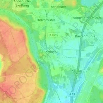
Name: Klettwitz topographic map, elevation, terrain.
Average elevation: 430 ft
Minimum elevation: 364 ft
Maximum elevation: 528 ft
Make a donation
Gear up for your next adventure:
As an Amazon Associate, this site earns from qualifying purchases at no extra cost to you.
Other topographic maps
Click on a map to view its topography, its elevation and its terrain.
Lübbenau/Spreewald
Germany > Brandenburg > Oberspreewald-Lausitz - Górne Błota-Łužyca
Average elevation: 197 ft
Schipkau
Germany > Brandenburg > Oberspreewald-Lausitz - Górne Błota-Łužyca
On September 19th, 2024 construction work on GICON High-Altitude Wind Turbine in Klettwitz wind park, which belongs to Schipkau, started. It will have a nacelle height of 300 metres and a rotor diametre of 126 metres. When completed, it will not only be the tallest wind turbine in the world, but also the…
Average elevation: 404 ft
01983
Germany > Brandenburg > Oberspreewald-Lausitz - Górne Błota-Łužyca > Großräschen
Average elevation: 407 ft
Senftenberg
Germany > Brandenburg > Oberspreewald-Lausitz - Górne Błota-Łužyca
Average elevation: 361 ft
Make a donation
Gear up for your next adventure:
As an Amazon Associate, this site earns from qualifying purchases at no extra cost to you.